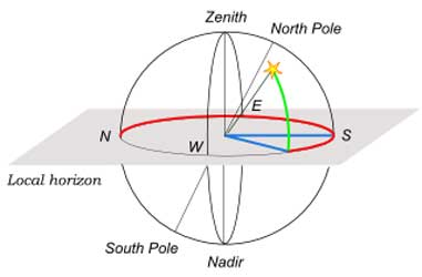
HORIZONTAL COORDINATES. Azimuth, from the North point (red) -also from the South point toward the West (blue). Altitude, green. (*) The horizontal coordinate system is a celestial coordinate system that uses the observer's local horizon as the fundamental plane. This conveniently divides the sky into the upper hemisphere that you can see, and the lower hemisphere that you cannot (because the Earth is in the way). The pole of the upper hemisphere is called the zenith. The pole of the lower hemisphere is called the nadir. The horizontal coordinates are: * altitude (Alt), sometimes referred to as elevation, that is the angle between the object and the observer's local horizon. * azimuth (Az), that is the angle of the object around the horizon, usually measured from the north point towards the east. In former times, it was common to refer to azimuth from the south, as it was then zero at the same time the hour angle of a star was zero. This assumes, however, that the star (upper) culminates in the south, which is only true for most stars in the Northern Hemisphere. The horizontal coordinate system is sometimes also called the az/el[1] or Alt/Az coordinate system. General observations The horizontal coordinate system is fixed to the Earth, not the stars. Therefore, the altitude and azimuth of an object changes with time, as the object appears to drift across the sky. In addition, because the horizontal system is defined by your local horizon, the same object viewed from different locations on Earth at the same time will have different values of altitude and azimuth. Horizontal coordinates are very useful for determining the rise and set times of an object in the sky. When an object's altitude is 0°, it is on the horizon, if at that moment its altitude is increasing, it is rising, if its altitude is decreasing it is setting. However all objects on the celestial sphere are subject to the diurnal motion, which is always from east to west, so the inherent cumbersome determination whether altitude is increasing or decreasing can be easily found by considering the azimuth of the celestial object instead (referenced to North as 0°): * if the azimuth is between 0° and 180° (north—east—south), it is rising. * if the azimuth is between 180° and 360° (south—west—north), it is setting. There are the following special cases: * At the north pole all directions are south, and at the south pole all directions are north, so the azimuth is undefined in both locations. A star (or any object with fixed equatorial coordinates) has constant altitude, and therefore never rises or sets when viewed from either pole. The Sun, Moon, and planets can rise or set over the span of a year when viewed from the poles because their right ascensions and declinations are constantly changing. * At the equator objects on the celestial poles stay at fixed points on the horizon. Note that the above considerations are strictly speaking true for the geometric horizon only: the horizon as it would appear for an observer on sea level on a perfect smooth Earth without atmosphere. In practice the apparent horizon, which you see, has a negative altitude, which absolute value gets larger when you come higher, due to the curvature of the Earth. In addition the atmospheric refraction adds another 0.5° to that value. Transformation of coordinates It is possible to convert from the equatorial coordinate system to the horizontal coordinate system and back, once the observer's geographic latitude φ is known (+90° on the north pole, 0° on the equator, -90° on the south pole). We will use A for the azimuth, a for the altitude. We will use δ for the declination, H for the hour angle. equatorial to horizontal
One may be tempted to 'simplify' the last two equations by dividing out the cosa leaving one expression in tanA only. But the tangent cannot distinguish between (for example) an azimuth of 45° and 225°. These two values are very different: they are opposite directions, NE and SW respectively. One can do this only when the quadrant in which the azimuth lies is already known. If the calculation is done with an electronic pocket calculator, it is best not to use the functions arcsin and arccos when possible, because of their limited 180° only range, and also because of the low accuracy the former gets around ±90° and the latter around 0° and 180°. Most scientific calculators have a rectangular to polar (R→P) and polar to rectangular (P→R) function, which avoids that problem and gives us an extra sanity check as well. The algorithm then becomes as follows. * Calculate the terms right of the = sign of the 3 equations given above * Apply a R→P conversion taking the * The angle part of the answer is the azimuth, an angle over the full range of 0° to 360° (or -180° to +180° etc) * Apply a second R→P conversion taking the radius part of the last answer as the X and the sina of the first equation as the Y value * The angle part of the answer is the altitude, an angle between -90° and +90° * The radius part of the answer must be 1 exactly, or you have made an error. horizontal to equatorial
The same quadrant considerations from the first set of formulas also hold for this set. The position of the Sun There are several ways to compute the apparent position of the Sun in horizontal coordinates. Complete and accurate algorithms to obtain precise values can be found in Jean Meeus's book Astronomical Algorithms. Instead a simple approximate algorithm is the following: Given: * the date of the year and the time of the day * the observer's latitude, longitude and time zone You have to compute: * The Sun declination of the corresponding day of the year, which is given by the following formula:
where N is the number of days spent since January 1. * The true hour angle that is the angle which the earth should rotate to take the observer's location directly under the sun. o Let hh:mm be the time the observer reads on the clock. o Merge the hours and the minutes in one variable T = hh + mm/60 measured in hours. o hh:mm is the official time of the time zone, but it is different from the true local time of the observer's location. T has to be corrected adding the quantity + (Longitude/15 - Time Zone), which is measured in hours and represents the difference of time between the true local time of the observer's location and the official time of the time zone. o If it is summer and Daylight Saving Time is used, you have to subtract one hour in order to get Standard Time. o The value of the Equation of Time in that day has to be added. Since T is measured in hours, the Equation of Time must be divided by 60 before being added. o The hour angle can be now computed. In fact the angle which the earth should rotate to take the observer's location directly under the sun is given by the following expression: H = (12 - T) * 15. Since T is measured in hours and the speed of rotation of the earth 15 degrees per hour, H is measured in degrees. If you need H measured in radians you just have to multiply by the factor 2π/360. * Use the Transformation of Coordinates to compute the apparent position of the Sun in horizontal coordinates. Retrieved from "http://en.wikipedia.org/"

|
|
||||||||||||