|
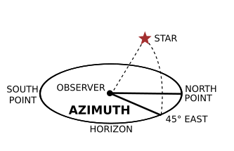
Azimuth is a mathematical concept defined as the angle, usually measured in degrees (°), between a reference plane and a point. This concept is used in many practical applications including navigation, astronomy, mapping, mining and artillery. The word azimuth is derived from the Arabic السمت ('as-sumūt') which means the ways, referring to the ways or directions a person faces. Navigation In navigation, the reference plane is typically true north and is considered 0° azimuth. Moving clockwise, a point due east would have an azimuth of 90°, south 180°, and west 270°. Some navigation systems use south as the reference plane. However, any direction can serve as the plane of reference, as long as it is clearly defined for everyone using that system. True north-based azimuths
Mapping There are a wide variety of azimuthal map projections. They all have the property that directions (the azimuths) from a central point are preserved. Some navigation systems use south as the reference plane like in the Philippine practice. However, any direction can serve as the plane of reference, as long as it is clearly defined for everyone using that system. Astronomy Azimuth is often, some consider incorrectly, referred to as a bearing. However, in modern astronomy azimuth is nearly always measured from the north. In former times, it was common to refer to azimuth from the south, as it was then zero at the same time the hour angle of a star was zero. This assumes, however, that the star (upper) culminates in the south, which is only true for most stars in the Northern Hemisphere. Other uses Azimuth is used to determine headings or the direction in which to fly. In artillery, it is the direction of fire. Azimuth is also terms used in mining for a similar, but slightly different angle: azimuths and meridian angles are used to name any angle measured clockwise from any meridian. For tape and cassette tape decks, azimuth refers to the angle between the tape head(s) and tape. For magnetic tape drives, azimuth refers to the angle between the tape head(s) Other systems Declination If instead of measuring from and along the horizon the angles are measured from and along the celestial equator, the angles are called declination and right ascension (hour angle). Horizontal coordinate In the horizontal coordinate system, used in celestial navigation and satellite dish installation, azimuth is one of the two coordinates. The other is altitude, sometimes called elevation above the horizon. See also: Sat finder. Polar coordinate In three-dimensional polar coordinate systems, including cylindrical coordinates and spherical coordinates, the azimuth of a point is the angle between the positive x-axis and the projection of the vector onto the xy-plane (the component of the vector in the xy-plane). In cylindrical coordinates, theta θ is almost universally used to represent the azimuth in mathematical applications, whereas physical applications may denote the azimuth using the symbol phi, φ. Although there are several conventions in spherical coordinates, the azimuth is usually denoted by either theta, θ or phi, φ. See also * Panning (camera) * Inclination * Longitude * Magnetic declination * Zenith Retrieved from "http://en.wikipedia.org/"

|
|
||||||||||||||||||||||||||||||||||||||||||||||